Overview
France is located in western Europe. The French coast is very extensive (4,170 km), opening onto the Mediterranean Sea, the Atlantic Ocean, the Channel and the North Sea. The neighbouring countries are Belgium and Luxembourg to the north; Germany, Switzerland and Italy to the east; and Spain to the south. French people are a Western European ethnic group and nation that shares a common French culture, ancestry, and the French language. The official language is French. Languages like Corsican, Alsatian, Basque and Breton are still spoken in their respective regions and were reintroduced into educational programmes from the 1980s. Nowadays, Arabic is the largest minority language, reflecting the fact that France colonised North Africa and has experienced inward migration from this region. Migrants also come from West Africa, the Middle East and East Asia. Successive governments have defined France as an inclusive nation with universal values, and advocated integration through which immigrants were expected to adhere to French values and cultural norms. French people can also be found internationally, in the overseas departments and territories of France such as the French West Indies, La Réunion and Mayotte (in the Indian Ocean), New Caledonia and French Polynesia (in the Pacific Ocean).
France was the first country in Europe to become a republic, in 1792. Overthrowing the monarchy, the republic as a system of government and model of sovereignty subsequently developed into nothing less than a comprehensive worldview. Whereas the First Republic lasted only a few years, the four Republics that France has known since the middle of the nineteenth century have all been based on a constitution. Since 1958, France has been a semi-presidential republic with a head of government – the prime minister – appointed by the president, who is the directly elected head of state. France was one of the founding member states of the European Union. France’s territory consists of 18 administrative regions: 13 metropolitan (i.e. European France) and five overseas regions. All five of the overseas regions as well as Saint Martin (a French territory in the Caribbean) are considered part of the EU (with the status of outermost region).
General information
| Name of country | France |
| Capital, population of the capital (2020) | Paris, 2,154,092 (Eurostat) |
| Surface area | 549,087 km² (World Bank) |
| Total population (2020) | 67,571,107 (World Bank) |
| Population growth rate (2010-2020) | 3.91% (World Bank) |
| Population density (2020) | 123.4 inhabitants/km² (World Bank) |
| Degree of urbanisation (2015) | 35.84% densely populated areas (European Commission) |
| Human development index (2021) | 0.903 (Human Development Reports) |
| GDP (2019) | EUR 2,155,350 million (World Bank) |
| GDP per capita (2019) | EUR 31,984 (World Bank) |
| GDP growth (2014-2019) | 8.48% (World Bank) |
| Unemployment rate (2019) | 8.41% (World Bank) |
| Land use (2018) | 6.0% built-up land 58.65% agricultural land 27.98% forests and shrubland 5.78% nature 1.59% inland waters (European Environment Agency) |
| Sectoral structure (2017) | 78.8% services and administration 19.5% industry and construction 1.7% agriculture and forestry (Central Intelligence Agency) |
To ensure comparability between all country profiles, the tables were prepared by the ARL.
Administrative structure and system of governance
State administration
The highest decision-making bodies of the state administration are the parliament, the government and the president. In addition, independent courts hold judicial power. The respective roles of these entities are defined in the Constitution of the Fifth Republic, which was adopted in 1958.
France has a semi-presidential system. The president of the Republic is elected for a term of five years by direct universal suffrage. The president appoints and terminates the appointment of the prime minister. On the recommendation of the prime minister, the president of the Republic appoints the other members of the government and terminates their appointments. The powers of the president extend to the option of submitting to a referendum any government bill which deals with the organisation of the public authorities, or with reforms relating to economic or social policy, or which provides for authorisation to ratify a treaty. The president may also declare the National Assembly dissolved, thus triggering new elections.
The French parliament comprises two chambers: the National Assembly and the Senate. The 577 members of the National Assembly are elected by direct suffrage on a five year mandate. The 348 senators are elected by indirect suffrage. According to the constitution, the Senate ensures the representation of the territorial communities of the Republic. Both the prime minister and members of parliament have the right to initiate legislation. Similarly, amendments, which are proposals to modify bills submitted for discussion, can be introduced by the government as well as by members of parliament. The role of parliament is to pass laws. It also monitors the actions of the government and more generally it assesses public policies. MPs and senators can question ministers, either in writing or orally. They can set up committees of enquiry and committees to collect information. In addition, the National Assembly can force the government to resign by voting on a motion of censure. The National Assembly shares legislative power with the Senate, but if the two chambers of parliament do not reach an agreement on a particular bill, the National Assembly has the final say.
The central authority of the state (administrations centrales) is made up of authorities whose decisions can be applied throughout the national territory. They are the highest administrative authorities and combine administrative and political functions. They generally have their headquarters in the capital, Paris. From Louis XIV to the Fifth Republic, France has long had a highly centralised administrative system in which decision-making power is concentrated at the top of the state apparatus. Since 1964, deconcentration has functioned to shift the control and implementation of government actions to the grassroots. The aim was to decongest the central administration by allowing decision-making to take place at the local level. Deconcentration differs from decentralisation in that it is a system of delegation to lower internal echelons that therefore have no legal personality of their own, whereas decentralisation delegates to local authorities with their own legal personality.
Regional and county administration
France is divided into 18 regions (régions), of which 13 are on the mainland and five are overseas. The regions were further subdivided into 100 departments (départements) and around 35,000 municipalities (communes) in 2019. In 1789, during the Revolution, the monarchy was abolished abruptly and a new local institutional system creating communes and départements was set up (Wollmann 2000). However, local authority was in the hands of the local representative of the national government (préfet). During the late 19th century, local representatives were elected and gradually given authority.
The creation of a regional tier of government (région) at the beginning of the 1980s was part of a wider project of halting centralisation. Decentralisation has moved the centre of gravity of French administration to local authorities. Regions are managed by a regional council (conseil régional) made up of representatives voted into office in regional elections every five years. The councillors elect their own president who heads the Regional Executive. Regions deal with economic development, regional planning, vocational training, the construction and maintenance of high schools and intercity transport. They have considerable budgets but they lack separate legislative authority and therefore cannot draft their own statutory laws.
Similarly, each department is administered by an elected body called a departmental council (conseil départemental). The councillors are elected every six years and they in turn elect a president. The main areas of responsibility of the departmental councils include the management of a number of social and welfare allowances, the building of junior high schools, and local roads. The local services of the state administration are traditionally organised at departmental level. However, regions have gained importance since the 2000s, with some department-level services merged into region-level services.
Local administration
Municipalities (communes) are the fourth-level administrative divisions in France. They are governed by officials who are elected every six years. The members of the council (conseil municipal) then elect the mayor (maire) who has extensive autonomous powers. The main competences of a French municipality are urban planning, housing, the environment, and the management of pre-elementary and elementary schools. France has not experienced a major reduction in the number of municipalities. Today, 86% of municipalities have fewer than 2,000 inhabitants. They vary widely in size and area, from large sprawling cities with millions of inhabitants like Paris, to small hamlets with only a handful of inhabitants. Perhaps as a result of this situation, France presents a strong case for intermunicipal cooperation. All municipalities, whatever their size or geographical position, are currently involved in voluntary groupings (Demazière 2021). The earliest form of cooperation, for which some of the founding principles date back to the end of the nineteenth century, related to managing waste, infrastructures, streetlights, etc. Where municipalities decided to cooperate, often the closer links went no further than pooling a few services. Against this background, the national government has adopted more of a directive role, seeking to strengthen intermunicipal cooperation and to make it common practice. In 1999, the law on strengthening and simplifying intermunicipal cooperation (loi relative au renforcement et à la simplification de la coopération intercommunale, known as the loi Chevènement) has favoured the creation of new voluntary groupings (établissement public de coopération intercommunale, EPCIs) to which municipalities transfer resources and competences such as economic development, transport and housing. These EPCIs are eligible for major government subsidies, which has encouraged municipalities to engage in them. Although the elected members of these structures are elected at the municipal level and not directly to the EPCIs, the latter must be considered an important level of French territorial authority.
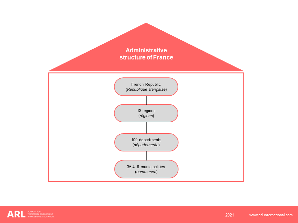
Figure 1: Adminstrative structure of France
French politics and state administration
The Constitution of the Fifth Republic declares the following principles: the accountability of the president of the Republic to the people, and the accountability of the government to parliament. The president is elected by direct universal suffrage, which gives them great legitimacy. In addition, the president can initiate a legislative referendum, thus bypassing parliament. The founder of the Fifth Republic, General de Gaulle, launched four referenda in ten years. In 1969, the reform of the Senate and the creation of regions met with a negative vote, leading to the voluntary resignation of de Gaulle. The referendum is therefore a formidable weapon. In 2005, the ‘no’ vote prevailed over the draft European Constitution. Despite the severe disavowal of this result, Jacques Chirac replaced the prime minister, but remained in office. Since then, no referendum has been held.
The prime minister is appointed by the president of the Republic. The prime minister’s key role is to coordinate the actions of ministers. As for ministers, their powers are centred around two main missions. On the one hand, they head a ministerial department. In addition, ministers are responsible for the supervision of public legal entities acting within their ministerial department’s field of competence. On the other hand, ministers are entrusted with a political mission. Their primary role is one of impetus and implementation of government policy. To do this, they interact with parliament and many stakeholders. The parliament has limited capacity to challenge the actions of the government. More than 100 censure motions have been tabled since 1958, but only one has been passed, showing the relative weakness of the National Assembly.
The French administration is characterised by a high number of civil servants. Indeed, the national government is the main employer of civil servants (2.4 million out of 5.5 million civil servants as of 1 January 2017), ahead of local authorities (1.9 million) and the hospital system (1.2 million). This proportion is different in other European countries, like England and Germany, where the state civil service is quantitatively in the minority. This distribution, an indication of French centralisation, has changed as a result of decentralisation since 1982.
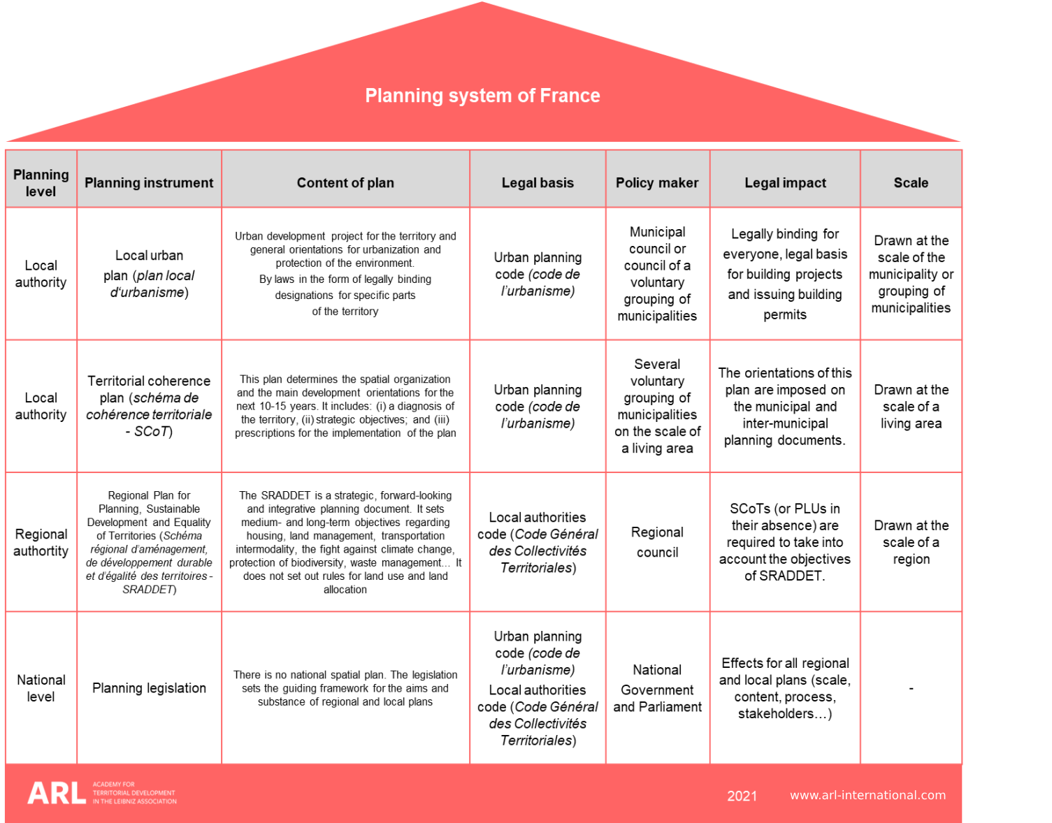
Figure 2: Planning system of France
Subnational levels of government
To analyse the role of sub-national government in France and how it has evolved over time, we may refer to the classic typology which distinguishes between northern and southern European models (Page and Goldsmith 1987). The criteria used are the extent of the functions assigned at the local level, the legal discretion left to the local authorities and the access of local politicians to the national government. France appears to be a ‘southern country’ where responsibilities and discretion are traditionally weak, but where there is access to central decision-making through the role played by a number of local elected representatives at the national level. However, since the early 1980s, France has undergone a process of decentralisation that has strengthened the prerogatives of all levels of local authorities. The three levels of local government are freely managed by elected councils, using their own resources (local taxes) and allocations from the state. The constitutional reform in 2003 and the ensuing legislation represented further steps in terms of sharing revenue-raising powers between state and local governments. Local authorities nowadays contribute to nearly 60% of all public investment in France. They enjoy a high degree of financial autonomy with around 50% of their local revenue being generated by local taxes. To levy taxes, many French municipalities, as well as the departments and the regions, have promoted the setting up of companies, job creation and housing development. However, territorial competition can be costly when similar public investments (e.g. conference centres, business parks, etc.) are made in neighbouring municipalities to further stimulate economic development. Vertical coordination between the three tiers of government is also lacking as none exercises control over another. An extreme example can be quoted in Marseilles, where two museums dedicated to Mediterranean culture opened in 2013, one financed by the municipality and the other by the region (Demazière 2018).
After 2012, the deterioration of France’s public accounts forced the national government, under pressure from the European Commission, to reduce public spending. From 2015, for the first time since the decentralisation laws of the early 1980s, the state decreased its grants to local authorities by a total of EUR 11 billion. In addition, two successive reforms of local authorities were carried out between 2010 and 2016. In 2009, an official report to President Nicolas Sarkozy proposed the comprehensive national coverage of intercommunal cooperation, the reduction of the number of regions through mergers, and the creation of metropolitan governments. Only the first of these was realised. From 2010 to 2017, the number of EPCIs was halved, while the proportion of the population covered by an EPCI increased from 89.1% to 100%.
In 2015, under President Hollande, the law on the New Territorial Organisation of the Republic (loi portant sur la nouvelle organisation du territoire de la République, NOTRe) clarified the responsibilities of the different levels of territorial authorities. The departments were weakened, being largely confined now to the maintenance of the road network and the payment of social benefits. The number of regions was reduced from 22 to 13, plus five regions overseas. In addition, the law on the modernisation of territorial public action and the affirmation of metropolises (loi de modernisation de l’action publique territoriale et d’affirmation des métropoles, MAPTAM) designated métropoles on the basis of their previous status and their having more than 400,000 inhabitants in a city region comprising over 650,000 inhabitants. This reform met with strong opposition from many mayors of small municipalities, notably in the two largest French city regions, Paris and Marseille. In Lyon, on the contrary, the heads of the department and of the EPCI have agreed to create a métropole by partly merging them. The two local elected representatives, who were also senators, then used their influence with parliament and the government to have their political agreement recognised by law (Demazière 2021). With its tailor-made status, the Metropole de Lyon is the most complete form of metropolitan governance in France, being the only métropole to be a fully-fledged local authority.
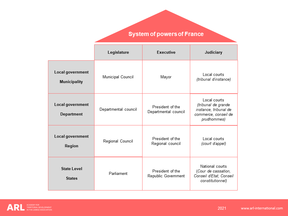
Figure 3: System of powers of France
Spatial planning system
Historical development of the French planning system since the Second World War
In France, the state has a historic power to implement urban policies and to define urban planning instruments. During the decades following the Second World War, Five-Year Plans were implemented at the national level with the aim of restoring production and infrastructure. An ambitious regional policy (aménagement du territoire) was launched in 1948 when Eugène Claudius-Petit, Minister of Reconstruction and Urban Planning, launched a National Regional Development Plan, initiating a genuine public policy to spread economic and demographic growth over the entire territory. In 1963, the DATAR (Délégation à l’aménagement du territoire et à l’action régionale) was created with this aim and it took many initiatives. Five new towns were designed in the Paris region (Évry, Cergy-Pontoise, Marne-la-Vallée, Sénart and Saint-Quentin-en-Yvelines) and four others in the provinces (Val-de-Reuil, Villeneuve-d’Ascq, l’Étang de Berre and L’Isle-d’Abeau on the fringes of the conurbations of Rouen, Lille, Marseille and Lyon). In parallel, the state compelled the municipalities of the largest conurbations outside Paris (Lyon, Lille, Bordeaux, etc.) to group together in intermunicipal cooperation bodies. In the rest of the country, so-called ‘medium-sized’ towns were subject to industrial deconcentration from the Paris region. In order to support local employment growth, housing was provided in large numbers. The development planning of medium-sized towns was seen as necessary to attract and retain a workforce from the countryside, where the mechanisation of agriculture was being imposed.
This spatial planning doctrine with a strong economic component was accompanied by new regulatory planning instruments. Master plans (Plans d’Urbanisme Directeur, later renamed Plans Directeurs d’Urbanisme) were guided by a key principle: the specialisation of space (Demazière 2018). France adhered to the Athens Charter’s functionalist principles, and 800,000 dwellings were built in the form of large housing estates in the outskirts of cities. Following the same logic, numerous industrial parks, shopping centres and university campuses were planned. France established a hierarchical system of land use planning in which the national government established guidelines for planning urban regions to which detailed local land plans by municipalities must conform. Adopted in 1967, the Land and City Act (Loi d’orientation foncière, LOF) set out the principle of the joint drafting, by the state services and the municipalities concerned, of two types of urban planning document: the Land Use Plan (plan d’occupation des sols, POS) and the Master Plan for Development and Urban Planning (Schémas directeurs d’aménagement urbain, SDAU), which was intended to set the guidelines for the development of a city region (Douay et al., 2014). In elaborating an SDAU, the views of the state services had more weight than the opinion of the local authorities, and the final approval of the plan was determined by the prefect. However, the SDAU had been conceived in a context of strong economic and demographic growth and the situation in the 1970s and 1980s proved much less favourable to planning (Douay et al. 2014).
From the beginning of the 1980s onwards, France underwent gradual decentralisation and planning power shifted to municipalities. From then on, the local plan (POS, later renamed Plan local d’urbanisme, PLU) was drawn up and approved by the commune and the Schéma Directeur replaced the SDAU. However, the state retains important prerogatives in defining higher-ranking legal norms and exercising the right to control the legality of the acts of decentralised authorities. In this relationship between the central and local levels, the territory is recognised as the ‘common patrimony of the nation’, from which it follows that ‘each public authority is the manager and guarantor within the framework of its powers’.
Spatial planning authorities responsible for spatial planning at each territorial level and the main spatial planning instruments
National level
Despite decentralisation, national authorities have sought to provide a framework for the exercise of local responsibilities in urban planning. First of all, various laws have been passed for certain high-stake areas, such as mountains and coastlines. Thus, in 1986, the law for the development, protection and enhancement of the coastline (loi pour l'aménagement et la protection et la mise en valeur du littoral) was passed on coastal development to protect such areas from real estate speculation and to develop free public access to coastal paths. In addition, certain instruments developed by the state have normative scope for local plans. At the junction of regional planning and land use planning, the territorial directives for sustainable development and planning (Directive territoriale pour l’aménagement et le Développement durable, DTADD) allow the state to supervise the production of local plans for certain territories that have specific environmental or social issues. The DTADD always concerns large territories whose definition is not constrained by administrative boundaries. Through this plan, the state declares its intentions with regard to a territory and provides a framework for the plans produced by local authorities.
Secondly, national interventions have aimed to put new topics for urban policies on the agenda of local authorities (Douay et al., 2014). Examples include the reduction of car use in the city, social cohesion at the scale of agglomerations, water quality, landscape protection, the fight against air pollution, etc. The state has also been involved in the development of a national policy for disadvantaged urban areas (politique de la ville). In doing so, national governments have created new instruments for local authorities. They have also reworked and made the hierarchy of plans more complex, notably creating a new planning level: the region.
Regional level
At the end of the 1990s, i.e. 15 years after regions were created, a law created the Regional Plan for Sustainable Regional Planning and Development (Schéma regional d’aménagement et de Développement durable du territoire, SRADDT). Developed and approved by regional councils, this forward-looking orientation document must describe the regional planning project. It must ensure that regional development projects are consistent with the policies of the state and the various local authorities where these policies have an impact on regional land use planning. The plan is intended to be a reference document for the regional authority for its policies. Depending on the interest shown by regional elected officials, the state of progress of the SRADDTs has been extremely variable. However, in 2015, the state persisted in entrusting the regions with the elaboration of a Regional Plan for Planning, Sustainable Development and Equality of Territories (Schéma régional d’aménagement, de Développement durable et d’Egalité des territoires, SRADDET). Compared to the SRADDT, the SRADDET was expanded to include new environmental aspects: energy management and recovery, the fight against climate change, biodiversity protection, waste management, etc. Above all, the objectives of the SRADDET must be taken into account in local urban planning documents. In this way, the regions acquire normative power over the projects of other local authorities. For this reason, all the regions concerned have adopted a SRADDET (Béhar et al. 2021).
At the local level
Decentralisation laws have resulted in the transfer of the bulk of urban planning powers and thus of local planning to around 35,000 communes. This competence was extended to intercommunal authorities by the Urban Solidarity and Renewal Act (loi Solidarité et Renouvellement Urbains, SRU) in 2000. The key elements are four instruments: the SCOT, PDU, PLH and PLU.
SCOT
At the scale of a living area, the territorial coherence scheme (schéma de cohérence territoriale, SCOT) is the pivotal document of urban planning law. This new plan replaces the master plan (SD). It aims to define a shared project at the scale of one or several groupings of municipalities. On 1 January 2020, France had more than 450 SCOTs covering 95% of the French population and 85% of the communes. These figures reflect a real revival of spatial planning in France. The SCOT describes a project of a political nature. It is not an operational instrument that can carry out actions, but it establishes a framework and constraints that ensure the conditions for carrying out these actions. It includes:
- a presentation report containing the assessment of the territory and the environmental assessment;
- a development and sustainable development project which presents the strategic objectives and choices in terms of development and environmental protection;
- a document describing the orientations and objectives which establishes how the plan must be implemented.
The SCOT has a legal framework that all other urban planning documents (PLU, PDU, PLH, etc.) must comply with by way of compatibility. Compared to the former SD, the SCOT is less focused on land use and more on strategy and foresight (Douay et al. 2014). With an objective of territorial coherence, this plan must deal with the major balancing acts of development (extension/renewal/protection of natural sectors), the social mix and the diversity of urban functions. It must also make it possible to better link urban planning and transport issues. The development of the SCOT is a concerted process between the EPCIs concerned, the state, the region, the department, but also representatives of the socio-economic sphere and associations. However, the realisation of the SCOT is made difficult by the size of the territory under consideration. The perimeters can take very diverse forms with generally several tens of communes of several groupings, but often have difficulty in taking into account the whole of a functional urban region (Cremer-Schulte 2014).
PDU
Since 1986, urban travel plans (Plan de déplacement urbain, PDU) have been mandatory documents in agglomerations of more than 100,000 inhabitants. They aim to improve the organisation of travel and transport and reduce car use in the city. The PDU is drawn up by the urban transit authority, usually one (or more) intermunicipal authorities. The state, the region and the department are involved in the procedure. Representatives of transport users, business and environmental associations may be consulted. PDUs should be compatible with DTADDs, SCOTs, and regional air quality plans. Conversely, PLUs must be compatible with the PDU. This interdependence of documents shows that developing alternatives to the car necessarily involves collaboration between multiple actors in the fields of urban planning and public transport, but also roads and parking, and consultation with economic actors, associations and citizens. In practice, the trade-offs between the development of road and public transport infrastructure are not always easy (Desjardins 2020).
PLH
The local housing programme (Programme local de l’habitat, PLH) was established by the decentralisation law of 1983. At that time, it represented just one way for communes or intercommunal bodies to define their housing priorities. The PLH became more extensive in 1991, when a law imposed a minimum quota of 20% social housing in municipalities in conurbations with more than 200,000 inhabitants. The PLH then became a plan to fight social segregation at the intermunicipal level. This orientation was reinforced in 2000, as the quota is now applicable to conurbations with more than 50,000 inhabitants.
PLU
In 2000, the SRU law transformed the land use plan (plan d’occupation des sols, POS) into a local urban plan (Plan local d’urbanisme, PLU) with the objective that the communes define an urban project and not just zoning. The PLU must articulate the design of an urban development project and the pre-operational dimensions of the development. Like the SCOT, the PLU has complex statutory objectives in terms of the diversity of functions and environmental protection, and it is drawn up by local elected officials at the municipal or intermunicipal level. The PLUs must therefore arbitrate the interests, which sometimes conflict, of the actors present on the territory, whether institutional, economic or from civil society.
The PLU includes a Sustainable Development and Development Project (Projet d’aménagement et de développement durable, PADD) and a by-law. The PADD sets out the EPCI’s or the municipality’s urban planning project and defines the general orientations of the policies for development, facilities, urban planning, the protection of natural, agricultural and forest areas, and the preservation or restoration of ecological continuity. It defines the general orientations for development and sets objectives for the intermunicipal moderation of the use of space. The by-law sets the general rules and easements for land use. It is opposable by any public or private person for the execution of any works or construction. The by-law may in particular:
- specify the use of land (use, nature of activities);
- define the rules relating to constructions and the external aspect of the constructions;
- specify, in urban areas, cultivated land to be protected and land which may not be used for construction;
- impose a minimum building density in areas close to existing and planned public transport.
The PLU must always be compatible with the SCOTs, PLHs and PDUs that are developed over larger territories. In most cases, the plan is carried out at the communal level. However, the state now encourages its replacement by the PLUI, with the ‘I’ meaning intermunicipal. The PLUI covers a larger territory than the PLU but it is also more integrative since it includes housing and transport planning guidelines, which are equivalent to the PLH and PDU respectively.
In France, planning was decentralised from the state to the municipalities in 1982. Since then, and especially with the reform of the planning system in 2000, a new attitude to planning has emerged, featuring a willingness to develop a project-oriented approach (Douay et al. 2014). In addition to addressing such basic issues as the regulation of land use and aggregating sectoral policies such as housing, transport, business activities or other infrastructure, the SCOT and the PLU are also conceived as a process to anticipate the character and location of key features of a place and to design the most efficient means for their execution and realisation. However, France has nearly 35,000 ‘communes’ and 86% of them have fewer than 2,000 inhabitants. This very large number of small municipalities results in local governments that lack planning capability and that autonomously make plans for such a small amount of land that there are inevitably incompatibilities and conflicts with adjacent communes. Furthermore, the ability of small municipalities to develop plans that comply with national laws and European directives that need to be respected is in doubt (Demazière 2018). Facing exogenous forces, such as international economic pressures or climate change, French spatial planning could be much more integrated and cross-disciplinary if more planning decisions were made at a higher level of government. This is the whole challenge of encouraging a greater use of SCOTs and PLUIs as mechanisms to connect the plans of individual communes. However, drawing up a SCOT requires dozens of mayors and hundreds of municipal councillors from a given city region to collectively define a spatial project on the scale of a very large territory. Moreover, the plan has a time horizon of 10–15 years, which far exceeds the duration of a municipal electoral mandate (six years). All of this can make it difficult for local public actors to develop a plan with real strategic content.
Another major challenge for the French planning system is that the full implications of the recent changes in the number, size and responsibilities of subnational government are as yet unknown. Over a short period of time, France has made major changes in how planning should be carried out. It is presently unclear how urban and regional planning will evolve. Intercommunal power is increasingly emphasised and the new regions (13 instead of 22) should have more influence on planning thanks to the SRADDET. But the existing relationships that were formed under the old rules now need to be readjusted to reflect the new rules (Béhar et al. 2021). This said, ‘the planning system context – that is, the legal and administrative structures – does not define planning activities completely. At most, it specifies corridors of action within which planning practice can move’ (Reimer et al. 2014: 5). France, where the planning system has undergone major changes, is a perfect case in point. Even though the principles of sustainable development have been adopted in legislation and in the constitution, the drafting of urban development plans still reflects local understandings, priorities and practices. The gap between the French legislator’s intention and common planning practice is not minor. Most plans are strategic and sustainable on paper, but the policy outcomes can be questioned as urban sprawl gains momentum.
Important stakeholders
| Institution/stakeholder/authorities | Special interest/competencies/administrative area |
|---|---|
| Centre d’études et d’expertise sur les risques, l’environnement, la mobilité et l’aménagement (Cerema) | This public establishment is under the joint supervision of the Minister of Ecological and Solidarity Transition and the Minister of Territorial Cohesion. With its multidisciplinary research potential, technical expertise and cross-disciplinary know-how, Cerema is active in the fields of development, housing, cities, transport, the environment, risk prevention, energy and climate. Its mission is to provide scientific and technical support for public policies for sustainable development and planning to all stakeholders (state, local authorities, economic players and associations). |
| Fédération nationale des agences d’urbanisme (FNAU) | The FNAU is an association that runs the network of 50 urban planning agencies in France. It is both a network of elected officials and a network of the 1,700 professionals who work in the agencies that promote exchanges of experience, the organisation of events and collective projects. FNAU works closely with local authority associations, ministries and network leaders at national and international level to contribute to debates on cities, urban planning and territories. |
Fact sheets
-
Fact Sheet France_Local Plan (PLU)_1.pdf (592.82 KB)
-
Fact Sheet France_Local Plan (SCOT)_1.pdf (927.62 KB)
-
Fact Sheet France_Regional Plan (SRADDET)_1.pdf (381.75 KB)
Attachments
-

Attachment 1: Topographic map of France
(source: Institut Géographique National, www.ign.fr) -

Attachment 2: Adminstrative map of France
(source: Observatoire des territoires, https://www.observatoire-des-territoires.gouv.fr/)
List of references
Béhar, D.; Czertok, S.; Desjardins, X. (2021): Faire région, faire France. Quand la région planifie, Paris: Berger-Levrault.
Central Intelligence Agency (2017): GDP – composition, by sector of origin. Available at: https://www.cia.gov/the-world-factbook/field/gdp-composition-by-sector-of-origin/ (Accessed 18 January 2023).
Cremer-Schulte, D. (2014): With or Without You? Strategic Spatial Planning and Territorial Re-Scaling in Grenoble Urban Region, Planning Practice and Research 29 (3), 287-301.
Demazière, C. (2018): Strategic spatial planning in a situation of fragmented local government: the case of France, disP - The Planning Review, Vol. 54(2), no. 213, 56-74 DOI 10.1080/02513625.2018.1487645
Demazière, C. (2021): Exploring the creation of the metropolitan city-region government: the cases of England, France and Italy, European Planning Studies, vol. 29, DOI 10.1080/09654313.2021.1923666
Desjardins, X (2020): Planification urbaine. La ville en devenir, Paris: Armand Colin.
Douay, N.; Nadou, F.; Demazière, C. (2014): Entre défi stratégique et contraintes institutionnelles pour la planification spatiale: le dialogue économie-environnement à Marseille et Nantes. In: J. Dubois (ed.), La construction métropolitaine face au développement durable, La Tour d’Aigues: L’Aube, pp. 236-261.
European Commission (2015): Global Human Settlement Layer. Available at: https://ghsl.jrc.ec.europa.eu/CFS.php (Accessed 18 January 2023).
European Environment Agency (2018): Land cover country fact sheets 2000-2018. Available at: https://www.eea.europa.eu/themes/landuse/land-cover-country-fact-sheets (Accessed 18 January 2023).
Eurostat (2020): Population on 1 January by age group, sex and NUTS 3 region. Available at: https://ec.europa.eu/eurostat/databrowser/view/DEMO_R_PJANGRP3/default/table?category=demo.demopreg (Accessed 18 January 2023).
Human Development Reports (2021): Human Development Index. Available at: https://hdr.undp.org/data-center/human-development-index#/indicies/HDI (Accessed 18 January 2023).
Page, E.; Goldsmith, M. (eds.) (1987): Central and Local Government Relations: A Comparative Analysis of West European Unitary States, London: Sage.
Reimer, M.; Getimis, P.; Blotevogel, H. (2014): Spatial Planning Systems and Practices in Europe. A Comparative Perspective, in Reimer M., Getimis P., Blotevogel H. (eds.), Spatial Planning Systems and Practices in Europe, London: Routledge, pp. 1-20.
Wollmann, H. (2000): Local government systems: from historic divergence towards convergence? Great Britain, France and Germany as comparative cases in point, Environment and Planning C Government and Policy, Vol. 18 (1), pp. 33-55.
World Bank (2020): World Development Indicators. Available at: https://databank.worldbank.org/source/world-development-indicators/Type/TABLE/preview/on# (Accessed 18 January 2023).