Overview
The Grand Duchy of Luxembourg is the second-smallest member state of the European Union (EU). The country occupies a territory of 2,586 km², with an altitude that ranges from 130 to 560 metres above sea level. The country’s main rivers are the Alzette, the Sauer and the Moselle, the latter two forming the major part of the border with Germany. Luxembourg forms part of the Low Countries, together with Belgium and the Netherlands. The Grand Duchy’s land-locked territory has borders with Belgium, France and Germany, with which the country has had strong economic relations since its independence in 1839. The socio-economic interdependencies between Luxembourg and its neighbouring regions of Wallonia (BE), Rhineland-Palatinate and Saarland (DE) and Grand Est (FR), forming the Greater Region of Saar-Lor-Lux+, have increased since the end of the 1980s due to the high rise in cross-border labour flows. As a result, just over 200,000 daily cross-border commuters contribute today to the Grand Duchy’s GDP, thus forming a substantial part of the country’s working day population (465,000 employees as of 2019). In other words, Luxembourg draws roughly 40% of its current workforce from the border areas in Germany (24%), France (52%) and Belgium (24%). While the majority of these commuters work in the capital city, others are concentrated in the formerly industrialised southern region and industrial sites around the capital and in the north of the country.
The country’s population has recently passed the threshold of 620,000 registered inhabitants (as of 1 January 2020). Economic and population growth have been persistent in recent times, rendering Luxembourg the only member state of the EU whose population record was positive across all municipalities. 52.6% of the population have Luxembourgish citizenship. Meanwhile, with 47.4% of the population represented by non-Luxembourgish citizens, the Grand Duchy thus has one of the highest shares of foreign population in the EU; the biggest foreign community is Portuguese with about 15% of the total population, followed by French, Italian, Belgian and German residents. In the capital, Luxembourg City, about 73% of the total population (122,000 by 2019) are foreign citizens. Overall, people from roughly 170 different nationalities were recorded as living in the small state in 2020. Luxembourg’s three official languages are Luxembourgish, French and German, while all official documents, enactments and laws are usually published in French. Other widely-spoken languages are Portuguese and Italian, and increasingly also English. These numbers illustrate not only the extent to which the country and its capital have been shaped by inbound migration in recent times; they are also part of a growth trajectory both in terms of demography and the labour market that seems to be unique, at least in the EU. As a result, the Grand Duchy’s population has increased since the late 2000s by about 10,000 new inhabitants per year. Since the 1990s, the economy has grown steadily by 2.5% to 4% annually, making for one of the highest GDPs per capita worldwide (to which the cross-border workers contribute quite significantly, yet without being included in this calculation).
Luxembourg is organised as a parliamentary representative democracy in the form of a constitutional monarchy, whose head of state is Grand Duke Henri II. Furthermore, Luxembourg has a unicameral parliamentary system with five-year terms. The national parliament, the Chamber of Deputies, comprises 60 members elected for a five-year term. The current government is chaired by Prime Minister Xavier Bettel from the Democratic Party (Demokratesch Partei, DP), which is part of a coalition government with the Socialist LSAP (Lëtzebuerger Sozialistesch Aarbechterpartei) and the Green Party (Déi Gréng), which has ruled the country since 2013. As part of the legislative procedure, the Chamber of Deputies is advised by the Council of State, a consultative organ which functions as an independent institution acting on all bills submitted to parliament. The Council of State’s 21 councillors are appointed by the Grand Duke. The Luxembourgish Constitution is a written constitution, which dates back to 1868. Since then it has been revised multiple times in order to respond to the requirements of a modern democracy. A major constitutional revision is currently under way. Luxembourg’s national political system is complemented by 102 municipal councils comprising between seven and 27 council members depending on the size of the municipality. Council members are elected in direct elections for six-year terms. Each municipal council is headed by one mayor and two to six deputy mayors (again depending on the municipality’s size), all appointed from among the elected council members. While elections take place according to the system of relative majority in municipalities with fewer than 3,000 inhabitants, elections are carried out according to a list system with proportional representation in municipalities with more than 3,000 inhabitants. There is no separation of offices between municipal councils and the national parliament.
Luxembourg is one of the six founding members of the EU and understands its particular role in European affairs as a small member state that is predestined to mediate between the large powers (such as France and Germany). Since the signing of the treaty establishing the European Coal and Steel Community (ECSC) in 1951, political, economic and societal support for European cooperation has remained very strong. As a result, the Luxembourg parliament has consistently approved European treaties and accession treaties either unanimously or at least by a very large majority.
General information
| Name of the country | Grand Duchy of Luxembourg |
| Capital, population of the capital (2019) | Luxembourg City, 122.273 (31.12.2019) |
| Surface area | 2,586 km² |
| Population (2019) | 626,1 |
| Population density (2019) | 242.1 inhabitants/km² |
| Population growth rate (year) | 1.8% in the commuting zone, 2.3% in the core (OECD 2018: 99) |
| Degree of urbanisation (year) | In urban or spatial terms, Luxembourg is dominated by small-town and rural settlements, which are low density and dispersed. Notable exceptions are the seven largest municipalities which account for 40% of the population (with the capital city region, also called the Agglolux area, comprising more than a quarter of the total number of residents), and 30% each for municipalities with a population of 5,000 to 10,000 or even less than 5,000 inhabitants. As a result of this, the degree of urbanisation could still be considered lower than in other countries, both in quantitative and qualitative terms. Therefore, calculations that treat the whole country as one metropolitan region (such as OECD 2018) are misleading in this respect. |
| Human development index (2019) | 909 |
| GDP (2019) | EUR 61.6 billion (IMF) |
| GDP per capita (2019) | EUR 116,639.89 (World Bank) |
| GDP growth (2019) | 2.6% (IMF) |
| Unemployment rate (2019) | 5.0% (IMF) |
| Land use (2019, Statec) | 37.5% forest and scrubland 0.6% inland waters 54% agricultural land 10% built-up land + 4.8% roads/railways |
| Industrial structure (2018, Statec) | 87.7% services and administration 11.1% industry and construction 1.2% agriculture and forestry |
Administrative structure and system of governance
Administrative structure (institutions)
The Grand Duchy of Luxembourg is a small but highly centralised unitary state with 102 municipalities forming the smallest territorial entity and de facto the only decentralised level of government. The municipalities have territorial and fiscal autonomies as set out in Articles 107, 99 and 102 of the Constitution. They operate and manage their assets and interests under the supervision of the Ministry of the Interior. Other than that, there is no intermediate level of administration, for example at the regional level, with its own competences and decision-making powers. Other territorial subdivisions are the districts and cantons. However, these units represent purely deconcentrated and functional territorial subdivisions used, for instance, for the administration of road works, road building and environmental issues, but do not play any significant role in routine politics or administration. Voluntary municipal collaborations have been set up in recent times, thus partly compensating for the non-existence of regional authorities in policy and planning (see below).

Figure 1: System of powers of Luxembourg
Central administration (functions and tasks)
The Luxembourgish government is currently composed of 24 ministries (including the Prime Minister’s Office). At the administrative level, ministries can be subdivided into ‘divisions’, ‘directorates’, ‘directorates-general’, or ‘services’, depending on the ministry; independent from the umbrella structure of the ministries, these departmental subdivisions remain the most important units in operational terms. The level of managerial autonomy (i.e. autonomy to establish work programmes) varies depending on the nature of the subdivision. Overall, there are three types of administrative entity, each equipped with different levels of managerial autonomy: (a) general services (services généraux) such as tax administration or customs administration, which are subordinate to a ministry and therefore lack a legal personality; (b) services with separate managerial autonomy (services à gestion séparée), such as the Center of Information Technologies (CTIE), possess greater financial autonomy and are thus allowed to set up their own annual budget using national allowances; (c) public agencies (établissements publics), such as the University of Luxembourg, the Post Office or the Savings Bank (Caisse d’Epargne de l’Etat), are separate legal entities that provide decentralised state services and cater for specific needs of general interest. As a result, the latter are autonomous in terms of management and financial planning. In the case of public agencies, the state exercises its role of managerial supervisor through its representatives on the various boards of governors, and also as the owner or main shareholder of these agencies.
As is typical of a small state, Luxembourg enjoys a certain freedom and flexibility to act in political and economic affairs, based on the clever use of the unique character of its sovereignty and short decision-making pathways. Small states have often proven successful simply by making a difference compared to their larger neighbours. This potential precipitated particularly clearly when the Grand Duchy started to become one of Europe’s most important financial centres, initially by offering lower taxes and less or little regulation in fiscal affairs compared to its neighbouring countries Belgium, France or Germany. These specific conditions helped to establish a business-friendly climate in terms of politics and administration. The country was and still is characterised by its openness to private initiative and investment and the allocation of public resources for this purpose. This seems virtually inscribed in the country’s DNA and also has important ramifications for the practice of planning and development (see below).
Municipalities (functions and tasks)
The law of 13 December 1988 lays down the general tasks and missions of the municipalities. Additional tasks are mentioned in special laws with regard to primary education, water supply and distribution, land use, social welfare and protection of the environment. The major basic responsibilities of the municipalities include the following: (a) drinking water supply and wastewater treatment, (b) waste disposal, (c) the protection against noise and air pollution, (d) the building and maintenance of the municipal roads network, (e) the issuing of municipal traffic decrees, (f) the administration of the population register, (g) the administration of cemeteries, (h) the issuing of police decrees in order to maintain public order and (i) the organisation of pre-schools and primary schools. One of the most essential tasks of municipalities in Luxembourg is undoubtedly (j) land use planning and land allocation, for which the local level has the sole authority and is only supervised in more formal regards by the state. Besides these basic public services, municipalities are permitted to offer additional services such as day care facilities for children, retirement homes, infrastructure for cultural and sports events and local public transport.
Local authorities are mostly only indirectly involved in the development of national policies, whether through the Association of Luxembourg Cities and Municipalities (Syndicat des Villes et Communes Luxembourgeoises, Syvicol), which is composed of local representatives and gives opinions concerning draft legislation which has an impact on the local level, or through approximately one-third of the Members of Parliament, who, due to there being no separation of offices, are national and local politicians at the same time. Such accumulation of offices in the tradition of the French system of députés maires is of course a very tricky conjuncture, which on the one hand comes with certain benefits in terms of knowledge flows, but may on the other give rise to all kinds of biases and complexities in policy making which could negatively affect both the national and the local policy levels alike. As a result, it looks as if a particularly strong representation of municipal interests is hampered by the somewhat ubiquitous nature of the state in all sorts of political processes.
Central administration (governance)
Governance at the level of the nation state can be characterised by its overall top-down culture, somewhat following a French (Napoleonic) tradition that is deeply rooted in the legal and politico-administrative constitution of the state. Recent times have also been characterised by the increasing involvement of private consulting companies in conceiving, implementing and guiding decision-making and internal management processes; the strong presence of the ‘Big Four’ companies of the accounting and consultancy industry in Luxembourg (namely KPMG, EY, PwC and Deloitte) is also exploited to include their specific knowledge and expertise in public policy innovation and management. The working style is generally rather pragmatic and can be best described as combining formal and informal practices, of which a certain dominance of the latter seems indicative of the small state setting: The country’s limited size and small administrative and political apparatus account for the relatively easy access of third parties to decision-making circles.
Luxembourg has rather small public administrations that often encounter administrative and, in some cases, even financial constraints when it comes to offering adequate public services due to their limited size and their limited levels of specialisation in-house. Ministries as well as their subordinate bodies show substantial differences in terms of know-how, expertise, resources, capacity and competencies both when it comes to policy development, management, implementation, monitoring and evaluation. Hence, the quality and efficiency of both administrative and political reforms may vary to a large extent across government. Therefore, the practice of importing knowledge and related advice from abroad (i.e. neighbouring countries) has a long tradition in Luxembourg, which is quite reasonable on the one hand, but also implies the need to take the considerable specificities of the small but sovereign country into account on the other hand.
Municipalities (governance)
Depending on the mission, municipalities exercise their authority either through the communal council, the board of the mayor and aldermen, or directly through the mayor. Each municipality has a central administration office, which consists of a secretary and, depending on its size, various departments or services (population office, planning department, technical service for municipal roads and infrastructure, green areas or public areas). In smaller municipalities, the secretary is in charge of all administrative tasks. The ‘technician’ who is in charge of many of these duties, particularly in smaller municipalities, compares well to the Gemeindesekretär in small towns in Switzerland.
The size of Luxembourg’s 102 municipalities varies greatly in terms of population and surface area (see above). This circumstance leads to complex issues in their everyday governance and management structures, particularly given the strong growth curves of the country’s demographic and economic development in recent times. Luxembourg City is by far the largest municipality with close to 125,000 inhabitants (2020, plus roughly 50,000 when counting its immediate neighbouring municipalities), followed by Esch-sur-Alzette (36,200 inhabitants, plus another 15,000 from the municipalities nearby), Differdange (27,400 inhabitants) and Dudelange (21,300 inhabitants) in the more densely populated southern parts of the country. In contrast, 57 municipalities have fewer than 3,000 inhabitants.
In recent years, the smaller municipalities in particular have been under constant pressure to keep up with the Grand Duchy’s economic and demographic growth. The traditionally small-scale administrative structures have been facing serious problems to adequately offer the full range of (required and additional) services to their citizens due to limited resources (both in terms of finances and staff). As a result, in an attempt to become more efficient, many services have been outsourced to private companies or are offered today by means of municipal syndicates or associations of municipalities. Over the past 20 years, the number of such municipal syndicates covering ever more extensive tasks and services such as drinking water supply, waste management, sports and leisure activities but also primary schools and child care facilities, has grown substantially. This trend gave rise in the early 2000 to calls for profound municipal reforms accompanied by demands for a fundamental redefinition of administrative structures or procedures and a redrawing of municipal borders, for instance by means of municipal mergers. Overall, ground-breaking public administration reform initiatives aimed at the municipal level have been rather moderate with just a few municipal mergers having taken place in the last ten years. The basic guiding principle of all governments since the early 2000s was that of voluntary mergers of municipalities (i.e. no ‘top-down’ political pressure). More profound was the impact of the 2017 municipal finance reform, which aimed at reducing major imbalances in yearly state allocations to Luxembourg’s 102 municipalities. The old funding formula, which was primarily tailored to the area of a given municipality and which mainly favoured larger rural municipalities, was exchanged for a modern funding formula in which, in addition to the number of inhabitants or the number of social housing units, a socio-economic index has been given more weight.
Especially densely populated municipalities and those that play a central or regional role according to national planning dispositions receive significantly more money from the state endowment fund due to this new calculation method. Apart from this profound municipal finance reform of 2017, there were some minor attempts to introduce initiatives aiming at management by objectives or the development of strategic work programmes. This did not have any impact on administrative structures and processes, which remained largely unchanged. It seems that the will for reforms may well have ebbed down, at least in the national political realm.
Spatial planning system
Historical development of the planning system
In comparison to other European countries, Luxembourg’s planning system is still relatively young. Up until the late 1990s, the country’s spatial planning regime was not sufficiently equipped in terms of legal instruments or institutions to steer the dynamic developments as mentioned in section 1 or to counteract unwanted spatial developments. It could even be said that, until the 1970s, spatial planning was of secondary importance. The municipal planning law of 1937 (Loi du 12 juin 1937 concernant l’aménagement des villes et autres agglomerations importantes) aimed primarily at technically-oriented land use planning by requiring all municipalities with more than 10,000 inhabitants, as well as ‘localities in the process of development, swimming resorts and places with a primarily scenic, artistic or historical character’, to draw up a development plan. While the 1974 revision of the municipal planning law of 1937 failed to change the overarching orientation of land use planning, it made general and partial development plans compulsory even for smaller municipalities in the Grand Duchy. Even the spatial planning law (Loi du 21 mai 1999 concernant l’aménagement du territoire) introduced in 1999 could not compensate for the limited conceptualisation of spatial planning in Luxembourg. This new spatial planning law of 1999 did indeed show a broader understanding of land use and included aspects such as quality of life, resource use, nature conservation and cultural landscape issues, and provided for a Higher Council for Spatial Planning (Conseil Supérieur d’Aménagement du Territoire) whose members are appointed directly by the Minister of Spatial Planning on the basis of their institutional affiliation and an Interministerial Committee for Spatial Planning (Comité Interministériel d'Aménagement du Territoire, only active until 2013) to assist the responsible ministry, but its impact remained minimal. The spatial planning orientations contained in the ‘Programmes directeurs’ of 1978 and 1988, drafted on the basis of the new spatial planning law, failed to materialise due to the lack of legally binding instruments, and also due to the rising development pressure that unfolded as a result of the country’s strong growth.
The introduction of the 1999 spatial planning law led to a paradigm change both in terms of instruments and institutions. Influenced by the European discourse on spatial planning (especially the European Spatial Development Perspective (ESDP) and the Territorial Agenda (TA)), the new law has contributed to modernising the legal basis of spatial planning in the Grand Duchy, to redistributing competences, encouraging interdepartmental coordination and providing ministries with the appropriate personnel and other resources.
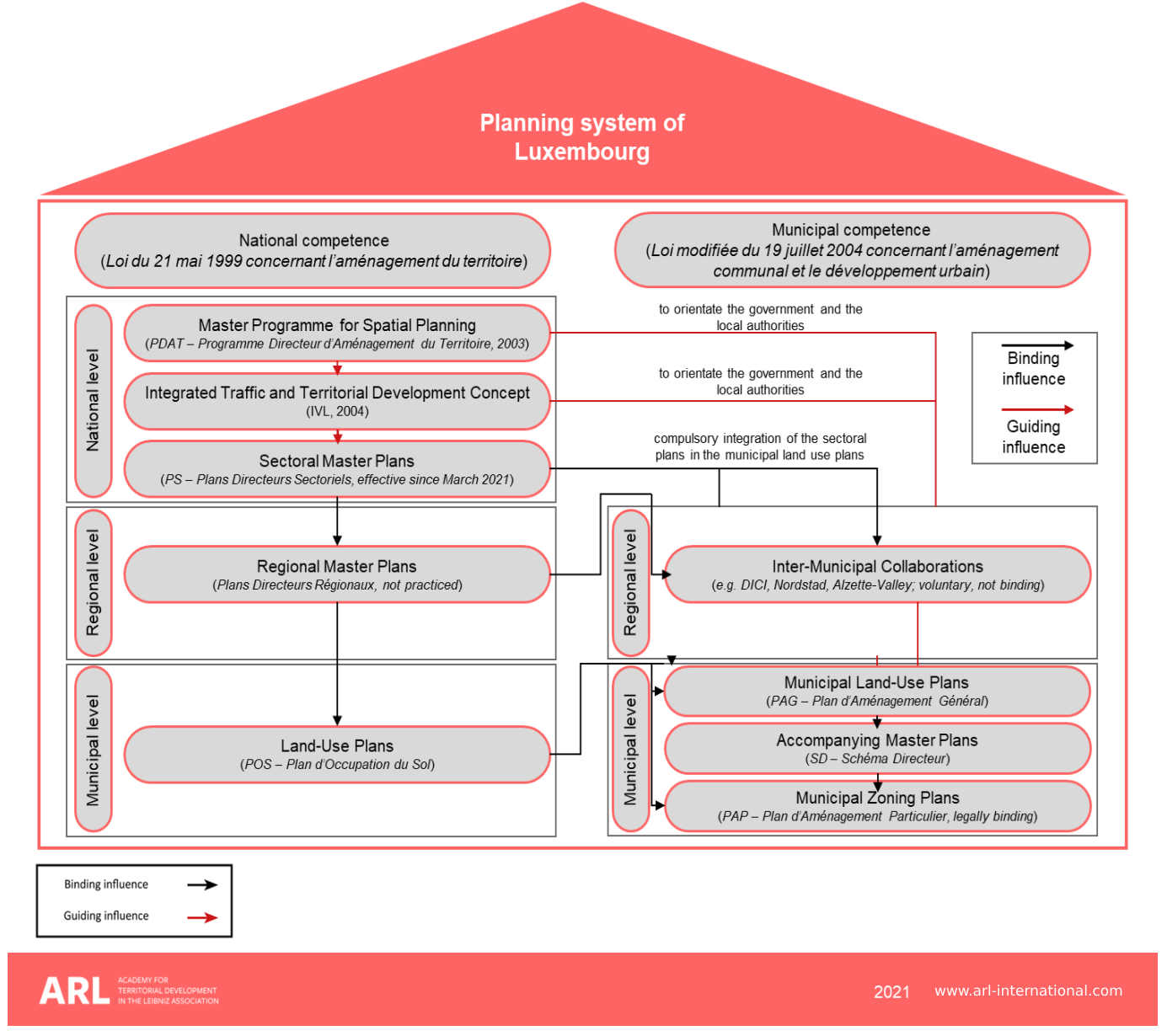
Figure 2: Planning system of Luxembourg
Legal basis/constitutional framework of spatial planning
Since 1999, the legal framework has been continuously revised and adapted with the aim to create a comprehensive legal framework that (a) encompasses Luxembourg’s two-tier institutional system with spatial planning competences against the background of a modern multi-level governance approach, (b) combines different formal and informal spatial planning instruments, and (c) takes an integrative approach in the sense of sustainable development. In this way, a planning system is emerging that is structured according to vested institutional responsibilities and specific spatial focal points.
In Luxembourg’s two-tier institutional system, both the national and the local level hold spatial planning competences. The national level first and foremost has the ministry responsible for spatial planning (currently the Ministry of Energy and Spatial Planning) and above all retains strategic competences via the 2003 orientation framework ‘Programme directeur de l’Aménagement du territoire’ (PDAT) and the 2004 Integrated Traffic and Territorial Development Concept (Integratives Verkehrs- und Landesplanungskonzept, IVL). The purpose of these instruments is mainly to define development objectives for the country’s future territorial structure and to coordinate the various sectoral policies on the basis of the 1999 law on spatial planning. These instruments also address fundamental questions such as how to deal with growth and how the territory is structured by means of the primary sectoral plans (plans directeurs sectoriels primaires) for mobility, housing, economic activity zones and large landscape ensembles. In addition, these primary sectoral plans, enacted as of March 2021, are envisaged to provide the national level with substantial regulative competences to counteract or at least to dampen the negative effects that arise from Luxembourg’s highly dynamic demographic and economic developments. A first draft of the four sectoral plans elaborated by the Ministry of Spatial Planning was presented back in 2014. They eventually had to be withdrawn due to legal inconsistencies and major public resistance as a result of a lack of coordination between the state and the local level with regard to policy objectives, plan content and implementation. In addition to the primary sectoral plans, there are special secondary sectoral plans (plans directeurs secondaires) tailored to integrate the construction of specific infrastructures into a territorial logic, three of which have entered into force so far: a sectoral plan for secondary schools (plan directeur sectorial ‘lycées’), a sectoral plan for landfill sites for inert waste (plan directeur sectorial ‘décharges pour déchets inertes’) and a sectoral plan for base stations for public mobile communications networks (plan directeur sectoriel ‘stations de base pour reseaux publics de communications mobiles’). The land-use plans (plans d'occupation du sol, POS) play a very special role: here the ministry in charge of spatial planning itself develops Land Use Plans for the municipal level. The municipalities, which are actually responsible for urban development at the local level, may only be involved as subordinate actors. This intervention in municipal autonomy is limited to cases of overriding importance, such as for Luxembourg’s international airport and surroundings. These regulatory tools are intended to link to the various national strategic tools and support their implementation.
On the other hand, there are 102 (to some extent very small) municipalities which, under the supervision of the Ministry of the Interior, have a long tradition of strong formal competences in land-use planning. Neither the revision of the municipal planning law from 2004 (Loi du 19 juillet 2004 concernant l’aménagement communal et le développement urbain) nor the subsequent reforms to the 2004 law (2008, 2011, 2013, 2017) have been able to significantly challenge municipal planning sovereignty, which unfolds mainly through the so-called “General and detailed land-use plan” (Plans d’aménagement general, PAG), the “Accompanying master plans” (plans d’aménagement particuliers, PAP) and the “General planning schemes” (schémas directeurs, SD). With the exception of the very few POSs, the PAG and PAP currently represent the only effective and legally-binding land-use planning instruments. To date, the latter ought to, but from a strictly legal point of view do not have to, respect the national strategic planning instruments. Attempts to make national strategic planning legally binding have been overturned by the Council of State. Furthermore, municipalities in core functional urban areas (Luxembourg City, South Region and Nordstad) are encouraged to engage voluntarily in strategic planning though informal forms of inter-municipal cooperation (i.e. Conventions Etat-Communes). Intended originally to achieve the strategic objectives laid out in the PDAT, these informal forms of cooperation are often used for strategic cooperation between municipalities on more concrete issues such as parking space management or inter-municipal bicycle lanes and economic activity zones.
Over the past 20 years, a complex spatial planning system has thus developed in Luxembourg in which considerable shifts of political forces can be observed: the system is characterised on the one hand by a much stronger state level that, in a ‘Napoleonic’ tradition of state agency, is increasingly trying to execute planning and thus get a grip on land-use decisions taken at the very local level. On the other hand, there are strong municipalities that are required to completely redraft their formal land-use plans and adapt them to the strategies defined at the national level while at the same time refusing to give up any of their municipal planning sovereignty. This new division of spatial planning power between the local and the national levels has become a source of major and to some extent destabilising conflicts, as the example of the sectoral plans shows. Such conflicts are bound to occur again and again unless it is ensured that participation during the development and implementation of spatial planning tools is taken seriously and that both parties meet on an equal footing.
Alongside the state and municipalities as the most important authorities in terms of spatial planning, it is important to note that state agencies in charge of implementing specific projects have played, and still play, an important role in the practice of planning and development in Luxembourg. This applies most notably to the two major public development funds that were created in order to realise major large-scale urban developments – the “Kirchberg Development and Urbanisation Fund” (Fonds d’Aménagement et Urbanisation de Plateau de Kirchberg, FUAK), created in 1961, and the “Belval Development Fund” (Fonds Belval), created in 2002, which is in charge of steering the development of public sites on the reconversion area of Belval in Esch-sur-Alzette and Sanem. Alongside the two public development funds, there is also Agora: a public-private development fund between the state and Arcelor/Mittal, whose objective is the reconversion of brownfield sites on the border between Esch-sur-Alzette and Sanem (Esch/Belval) and Esch-sur-Alzette and Schifflange (Alzette Quarter). The two public funds as well as the public-private fund were not only essential for the financing and implementation of development, but also became operational in spatial planning terms, thus taking over major responsibilities which were actually in the hands of the municipalities. The related tension has caused a range of conflicts between the two levels of governance, state and local.
Overview of the national spatial planning instruments
The most important national spatial planning instruments in Luxembourg are as follows:
- Master Programme for Spatial Planning (Programme Directeur d’Aménagement du Territoire, PDAT): The PDAT, prescribed in the new spatial planning law of 1999 and published in 2003, is the overarching strategic framework document regarding sustainable territorial development for national and local authorities. The principles, policy objectives and measures defined in the master programme will be put into practice through sectoral master plans and land use plans, for example. Integrative in its nature, the programme develops synergies between urban and rural development, transport and telecommunications and the environment. The PDAT stipulates the principle of deconcentrated concentration (déconcentration concentrée) as the key guiding principle of regional planning. In other words, it establishes the concentration of settlement development and infrastructure expansion in selected cities and municipalities according to different levels of centrality. By promoting such “Regional development centres” (Centres de développement et d'attraction, CDA) – cities and towns with a high degree of centrality – or by preventing the development of areas in places not classified as CDAs, a balanced development of all parts of the country should be ensured. At the same time the demographic and economic dominance of the capital is to be balanced out. The revision process for updating the current masterplan was officially launched in 2016. Between 2017 and 2019, a broad participatory process involving local politicians, NGOs, civil society and cross-border workers was conducted. The process consisted of four regional workshops with a total of almost 200 participants, in particular through the methodology of ‘collaborative change making’. Four regional laboratories were organized across the country, involving a total of almost 200 participants. So far, no draft version of the new master plan has been published.
- Integrated Traffic and Territorial Development Concept (Integratives Verkehrs- und Landesplanungskonzept, IVL): Completed in 2004, this development concept, as an insightful scientific analysis and non-binding medium-term strategy paper, has had a lasting impact on the planning debates and planning decisions in Luxembourg up to the present day. The IVL consists of a detailed analysis of the situation, and various scenarios for the expected development of the residential population and cross-border commuter flows up to 2020 were developed depending on the development of new jobs and residential construction activity. In the sense of ‘deconcentrated concentration’, the development concept defined 39 ‘IVL communities’ along the main settlement axes. These IVL communities are important in terms of urban development mainly because they have good transport connections and infrastructure (retail, schools, hospitals, etc.). The figures in the IVL regarding population growth as well as the growth of cross-border commuter flows became outdated rather quickly due to the substantial demographic growth in Luxembourg in the past 20 years. There are currently no plans to revise the IVL.
- Primary sectoral master plans (PS primaires – plans directeurs sectoriels primaires): The four primary sectoral plans (mobility, large landscape ensembles, economic activity zones and housing) can be seen as the future central regulatory instruments for spatial planning in Luxembourg. At present, they are still in the process of being adopted after a first draft of the plans was pulled from the law-making process. After the sectoral plans have come into force, they will comprehensively and bindingly allow for the implementation of the objectives of the PDAT.
- Secondary sectoral master plans (PS secondaires – plans directeurs sectoriels secondaires): Besides the primary sectoral plans, a series of secondary sectoral plans focusing on the territorial integration of particular infrastructures such as secondary schools, landfills and stations for public networks and mobile telecommunications were adopted between 2005 and 2006.
- Land-use plans (plans d’occupation du sol, POS): POSs include detailed land use provisions for areas of national importance such as for the national airport, military sites or refugee care structures. The POS de facto overrides municipal planning autonomy, as the national level takes over the planning sovereignty for these particular areas. The plans and regulations prepared by the national level thus replace the municipal land-use and building plans in those respective areas.
Overview of the municipal spatial planning instruments
- The municipal level is actually the only level in Luxembourg that provides legally binding plans for urban development – plans that become effective to concretely steer planning and building activities. Comparable to the situation in many other if not all European countries, we can distinguish between general land use plans on the one hand and particular building plans on the other. Municipal land-use plans (Plan d’aménagement general, PAG) determine the general direction of development (built-up versus open spaces) and also allocate certain land uses, such as lots reserved for housing purposes, areas for public use, office and mixed-use areas and the like. Municipal zoning plans (Plan d’aménagement particulier, PAP) contain detailed land use provisions for the use, protection and the design of larger plots of land or series of plots. They also prescribe features of the single buildings to be developed, such as their height, floor space and plot ratio. There are two different types of PAP in common use: PAPs for existing neighbourhoods (PAP quartier existant) and PAPs for new neighbourhoods (PAP quartier nouveau). According to the local building regulations (Règlement des Bâtisses), planning permission is required for the new construction, demolition and expansion of buildings. The application is usually submitted to the mayor’s office.
- Quite different from the large majority of other countries, the establishment of land use plans (both PAG and PAP) in Luxembourg is an activity that is not necessarily the responsibility of the municipality alone, but can be delegated to a planning consultancy or even to a private investor; in the latter case, the investor or developer is then obliged to engage expertise from a planning consultancy in order to ensure that the plan conforms to the usual requirements. This situation should probably be seen against the background of the limited size of the communes in the Grand Duchy, whose planning capacity is often limited. In this context, private engagement may make sense, and it is also in line with the country’s liberal approach to economic development. However, it can also be problematic when the various powers between private and public interests are unequally distributed and the vested interest of development and profit maximisation cannot be entirely limited throughout the planning process.
Practical examples
- Large-scale projects: Urban planning trajectories in Luxembourg accelerated in the early 1960s with the urban extension of the 365-hectare European quarter and banking district of Kirchberg, which is part of Luxembourg City. Kirchberg was the first and biggest in a series of large-scale projects pursued by the city and country to make space for the service industries and the European institutions in particular. This tendency to favour big projects, of which the new, EUR 1 bn university campus/science district in Esch-Belval is the most recent incarnation, became quite popular in Luxembourg: it promises to offer space for development, and in doing so, also allows for some experimentation with state-led financing and implementation. However, it also faces a range of problems, such as a dominance of office space, a related lack of urban integration, and high risks in relation to financing and implementation. Moreover, these projects are often placed in the fragmented, intricate environment of urban policy, characterised by small towns and municipalities and limited public planning capabilities on the part of local authorities. Finally, this specific ‘exceptional urbanism’ of Luxembourg unfolds a path dependency which seems difficult to modify in the short- or mid-term.
- A negotiative approach to planning: Land planning and urbanism in Luxembourg is first and foremost an activity that has made strong growth and economic development possible. However, exorbitant land prices and rents can be considered a downside of the country’s successful economic transition: land is scarce in absolute (the size of the Grand Duchy) and relative terms (the cycles in which lots are brought to the market), which has seen property become an important asset for both corporate and private actors. Landowners and developers are well positioned in the development process, while public institutions such as the municipalities do not have sufficient land resources to counteract them; often they also lack the power to determine land use and urban planning goals in the development process. As private corporations can also commission a planning consultancy to draw up land use plans on behalf of developers’ interests, municipal goals and strategies – to the extent that they even exist – can be difficult to assert. In such a negotiative setting, the scarcity of land and housing tends to be cultivated rather than to happen by coincidence. This could only be overcome by the development of a public policy for property and a higher weighting given to common rather than private interests.
- Spatial planning by event: A most recent trend of urban and spatial planning practice in Luxembourg is the organisation of temporary events and competitive processes, not only in architecture and urban design terms, but also as concerns planning and environmental visioning. By pursuing such measures, the government seeks to obtain inspiration for orienting spatial development in the future. These measures include the potential organisation of an International Building Exhibition (in its initially German blueprint called Internationale Bauausstellung) in the southern region of the country, the international competition for development proposals under the umbrella concept Luxembourg in Transition, and also the reformulation of the country’s main planning guideline Programme Directeur Aménagement du Territoire (PDAT). These activities may also bring a certain sense of strategic orientation to Luxembourg’s planning system, whose most recent strategic document was the Integrated Concept for Transport and Regional Planning (IVL) from 2004. While not providing any binding means for spatial planning (which exist at municipal level only), these concepts would however be challenged by the rather piecemeal planning and land development practice that has existed hitherto.
- Intermunicipal collaboration: After 2005, several informal partnership agreements for the promotion of integrated and sustainable urban development between the state and municipalities in key functional urban areas – so-called conventions – were put in place. The elaboration of these innovative planning instruments was guided by three main factors: (a) the realisation that without national control the competition between municipalities for business locations and construction projects in the context of nationwide demographic and economic development pressures, which have been ongoing since the 1990s, would lead to increasingly negative consequences; (b) the explicit requirement stipulated within the PDAT, published in 2003, for consistent intermunicipal cooperation as a key instrument for achieving national spatial planning goals; and (c) the desire to transfer the European urban policy approaches of integrated urban development and multi-level territorial governance to Luxembourg. Complementary to existing formal planning instruments, conventions were designed to encourage a more dynamic and flexible planning approach based on dialogue and the development of concrete projects. They consisted of an exchange of experience and knowledge at intermunicipal, inter-ministerial and multidisciplinary level, thus contributing to the emergence of a more participatory planning culture. The results of the process were rather mixed: apart from some minor but concrete pilot projects, the conventions did indeed produce some intermunicipal and regional development strategies such as the Nordstad Master Plan, the Uelzechtdall Mission Statement, the DICI Integrated Development Plan or even the Concept directeur du Sud. The development, however, was for the most part laborious and slow and the implementation far from consistent. The experience shows, firstly, that a collaborative multi-level governance culture cannot be prescribed in a top-down manner but has to grow incrementally. Second, it is a highly conflict-prone approach, which in a setting influenced by decades of consensus politics, leads to substantial frictions that even money cannot resolve. Even though almost all conventions expired by 2019, intermunicipal cooperation is still considered an indispensable tool in Luxembourg’s spatial planning system. In the future, new, integrated forms of intermunicipal cooperation are foreseen, for instance for Agglolux, the larger functional area around the capital city.
Important stakeholders
| Institution/stakeholder/authorities | Special interest/competencies/administrative area |
|---|---|
| Ministry of Energy and Spatial Planning | Programme Directeur de l’Aménagement du Territoire (PDAT) Integratives Verkehrs- und Landesentwicklungskonzept (IVL) Plans directeurs sectoriels primaires et secondaires (PS) Plans d’occupation du sol (POS) |
| Ministry of the Interior | Supervision of municipal land-use plans (PAG), zoning plans (PAP) and building regulations (RB) |
| Municipalities | Conventions Etat-communes Plan d’Aménagement Général (PAG) Plan d’Aménagement Particulier (PAP) Schéma Directeur (SD) Règlement des Bâtisses (RB) |
| Fonds Kirchberg | Public organisation for the urbanisation and development of the Kirchberg Plateau (in Luxembourg City) |
| Fonds Belval | Public organisation for the development of the City of Science, Research and Innovation in Esch/Belval |
| Agora | Public-private organisation in charge of the revitalisation of former brownfield sites in Esch/Belval and Esch-sur-Alzette/Schifflange |
| Department of Geography and Spatial Planning (University of Luxembourg) | Research on spatial planning and urban governance in Luxembourg, the Greater Region and Europe Continuous training course for spatial planners Masters in Geography and Spatial Planning |
| LISER | Housing and Spatial Development Observatory Research on spatial strategies |
| Syvicol | General representation of Luxembourg’s 102 municipalities Permanent consultation between municipalities on questions of municipal interest Interlocutor of the government in matters affecting general municipal interests Represents Luxembourg’s municipalities in European and international organisations Promotes cross-border and interterritorial cooperation |
| Conseil supérieur d’Aménagement du territoire | Advises and assists the government in spatial planning policy |
| Comité supérieur du développement durable | Discussion forum on sustainable development |
Fact sheets
-
Planning level National.pdf (418.37 KB)
-
Planning level Municipal.pdf (818.6 KB)
-
Planning level Inter-Municipal.pdf (600.35 KB)
Attachments
-

Attachment 1: Overview of the Country Luxembourg
List of references
Becker, T.; Hesse, M. (2020): A Temporary Space Where Development and Planning Emergencies Meet? Notes on an International Building Exhibition (IBA) in the Cross- Border Territories of France and Luxembourg, Planning Theory & Practice, DOI:10.1080/14649357.2020.1842588
Bousch, P., Chilla, T., Gerber, P., Klein, O., Schulz, C., Sohn, C., Wiktorin, D. (ed.) (2009): Der Luxemburg Atlas - Atlas du Luxembourg. Köln: Emons Verlag.
Decoville, A.; Durand, F. (2016): Building a cross-border territorial strategy between four countries: wishful thinking? European planning studies, 24(10), 1825-1843.
Dörry, S. (2015): Strategic nodes in investment fund global production networks: The example of the financial centre Luxembourg. In: Journal of Economic Geography 15 (4), 797-814.
Hesse, M. (2016): ‘On borrowed size and flawed urbanization: The exceptional urbanism of Luxembourg, Luxembourg’. European Urban and Regional Studies, 23(4), 612–627.
Katzenstein, P. J. (2003): Small states and small states revisited. New Political Economy, 8(1), 9-30.
Leick, A.; Hesse, M.; Becker, T. (2020): From the “project within the project” to the “city within the city”? Governance and Management Problems in Large Urban Development Projects Using the Example of the Science City Belval, Luxembourg, Raumforschung und Raumordnung, 78 (3). Available at: https://doi.org/10.2478/rara-2020-0009, (accessed 12 February 2021)
Pauly, M. (2018): Luxembourg et Kirchberg: ville médiévale et capitale européenne. In: Fray, J.-L. et al. (eds.): Urban Spaces and the complexity of cities, 273-288. Wien, Köln, Weimar: Böhlau (= Städteforschung, vol. 97).